Sunday, December 29, 2013

Saturday, December 28, 2013

Winter Experience - Turnagain Arm Ice Flow

Here's a quick clip of the tide running out in Turnagain Arm Alaska; it's filled with ice chunks.  This is early December and it hasn't been cold for very long, yet.  The ice pieces are too small to call icebergs but it's still a great show of mother nature's power.

Friday, December 27, 2013

Winter Hiking - Spitting in the Winter (Hiking the Homer Spit)

Ice flow on the east side of the Spit


Stats

Distance:  Up to you                       Difficulty: Easy                              Time:  Up to you

Summary

The Spit is a Homer landmark.  It is exactly what its name says, a spit of land reaching into Kachemak Bay.  In summer, the spit is best know for the fishing charters, shopping, and fish packing.  In the winter, the spit belongs to strollers, photographers, and dog walkers.

Opinion

In winter, this is still one of our favorite hikes.  

Friday, December 20, 2013

Winter Experience - Ice Falls on Turnagain Arm

Ice Falls

Each year, as the cold sets in, the landscape in Alaska shifts from green to white.  One of the most dramatic shits occur when the seeps and small waterfalls freeze.  

Thursday, December 19, 2013

Sunday, November 24, 2013

Hiking - Portage Glacier Trail (all the way to the beach)


Stats

Distance:  4.7 miles                  Difficulty: Strenuous                                Time:  5 hrs

Summary

We chose to try the Portage Glacier Trail on 10 Jul 2013.  The hike goes up a nearly continuous inclined for a 750 ft elevation change, then back down (more gently) the full 750 ft to reach the portage glacier lake.  We found the hike on the National Park Service map (NPS Portage Glacier Trail).  This page is useful, but someone dated, see The Hike section of this post for updated information.

Opinion

This is a fabulous hike!  But we wouldn’t recommend it to anyone who is not at least reasonably fit.  The highlights of the hike include

Thursday, November 7, 2013

Experience - Viewing Baby Moose

One of the cutest things in Alaska is a baby moose.  But standing very close-by is the most dangerous animal in Alaska; its mom.  Moose moms can weigh-in at as much as 1200 lbs.  Moose in Alaska usually give birth to twins and, at least in Homer, they are usually born from mid-May to early June.  Moose moms have babies every two years.  A few weeks before they give birth, the mother moose chases off her two year old(s); usually by then she only has one calf left.  So in April and May there are often a lot of confused and unhappy teenaged moose running around.

Moose give birth in a place they feel safe.  This used to mean in the middle of a pond or bog, but now that location is often in the middle of someone’s yard, a town park, or even (according to one story) a Walmart parking lot. 

Sunday, October 27, 2013

Experience - View from Skyline Overlook

If you’re in Homer and have 20 minutes to spare or can afford a short detour on the way out of town, 
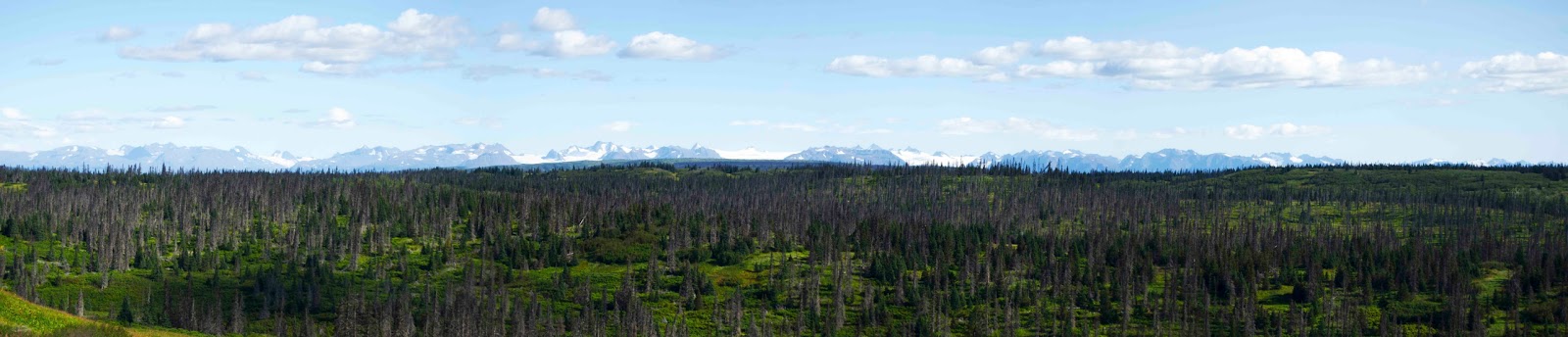
the scenic overlook on Skyline is a great choice.

A quick five-minute drive from town and three steps out of the car will bring you to one the best views in Homer.  Head up either East Hill or West Hill road until they merge with Skyline.  If you chose West Hill Rd, turn right; if you chose East Hill Rd turn left.  About a quarter mile from the intersection of Skyline Dr and East Hill Rd you'll find a pull off on the south side of the road (next a small antenna farm).  That pullout gives the best high-altitude view in Homer.  From this spot you have a fabulous 180-degree view of Kachemak Bay, the Homer Spit, and the Chugach Range.

We especially like the days where Homer is socked in with low clouds and the pullout is clear.  The entire valley and bay are covered in white cotton balls--often with peekaboo views of the spit, the coast, or the ocean--and the mountains across the bay stick up pass the clouds.  They have the feel of untouched wildness.


If you’re leaving town, you can follow Skyline Dr west along several miles until it intersects with Diamond Ridge Rd.  Diamond Ridge Rd intersects with Sterling Highway and it's a right turn to Soldotna, Seward, and Anchorage.  This route bypasses Homer proper and follows the ridgeline for several miles.

Tuesday, October 1, 2013

Adventure - Fishing with Dan Donich Charter – Full-Day Halibut Trip


Chris' 35 lb halibut ready to break the surface.


Stats

Difficulty: Easy - Moderate                                                                      Time:  Full-Day

Summary

I love halibut, but we don’t own a boat.   We decided to go on a fishing charter on 11 Sep on the hope of filling the freezer.  This time we chose Dan Donich (Daniel's Personalized Guide Service).  He was recommended by an acquaintance.  This was our second charter in 2013.  We went out on the Irish in late Aug (see Halibut Fishing with North Country Charters) and came home with 15.8 lbs of halibut filets, but we wanted more.

Opinion

Great trip!  My husband and I caught our limit (so did everyone else on the boat) and came home with 54.1 lbs of halibut filets

Wednesday, September 11, 2013

Adventure - Halibut Fishing with North Country Charters


The Take


Stats

Difficulty: Easy - Moderate                                                                      Time:  Half-Day

Summary

I love halibut, but we don’t own a boat.   So we decided to try halibut fishing.  For our first trip, we decided to try North Country Charters.  They were offering a ½ day halibut-fishing trip on 20 Aug that suited our needs.

Opinion

Good trip!  WIth day old or worst halibut running $21 to $25 per pound we decided to fill

Saturday, September 7, 2013

Story - Novices Go Fishing for Reds (Salmon)


Summary

This is the story of my husband’s and my experience when our neighbor took us fishing for Reds for the first time.  We thought the story was funny enough that true fishermen would find it funny and others would find it interesting.

The Story

Friday, September 6, 2013

Adventure - 4-Wheeling with Alaska Wilderness 4-Wheeler Tours in the Kenai Backcountry


Kachemak Bay Glaciers Seen from Kenai Backcountry

Stats

Difficulty: Easy - Moderate                          Distance: 15 mi                                 Time:  6 hrs+

Summary

Dan Eidem runs Alaska Wilderness 4-Wheeler Tours, a tour on ATVs, for small to medium groups.  An earlier post described our trip with him in May down the beach from Bishop’s Beach in Homer (AW4WT - On the Beach).  This time we took his more usual route, into the Kenai Peninsula backcountry.  This area includes meadows filled with Fireweed, spruce forests, sweeping vistas and views of glaciers and volcanoes.

Opinion

This trip was a blast!  We went several miles

Sunday, August 18, 2013

Adventure - Blueberry Picking at the Peterson Research Station


Sunset at Peterson Research Station

Stats

When: Early – Mid August                         Where: Peterson Research Station

Summary

Alaska seems to be the US capitol for berries.  More berries grow in this state than I’ve ever heard of anywhere else.  We’ve got blueberries, raspberries, blackberries, salmon berries, watermelon berries, elderberries, currant, marionberries, cranberries, lingonberries (low bush cranberry), nagoonberries, crow berries, serviceberries, and strawberries.  Most of these grow wild, but several cultivars are grown in home yards and farms as well.  Truly, I didn’t know half these berries existed until I moved here.

On 11 Aug 2013 our neighbors asked if we wanted to take a boat ride across Kachemak Bay to go blueberry picking at the Peterson Research Station.  The Peterson Research Station belongs to the Center for Alaska Coastal Studies based out of Homer.  The station is situated on 5 acres of wild land and coastline and their lower trails go through extensive blueberry fields, with a mix of currant and salmonberry randomly distributed throughout.  The berries are fair game to visitors, although they ask that you leave a few for the bears.

Opinion

This was a blast.  We picked berries for about 2 hours and came home with 7.5 lbs (22.5 cups)

Hiking - Eveline State Recreation Site outside Homer

Portlock and Dixon Glaciers from the Bottom of Alpine Meadows Loop

Stats 
Distance:  1.4 miles                   Difficulty: Easy                                 Time:  50 min

Summary
On 15 Aug 2013 we got a break in the much overdue rain and headed to the Eveline State Recreation Site.  Eveline has trails that are used in both summer and winter.  The summer trails are two loops: Glacier View Loop and Alpine Meadows Loop.  Both trails are inland meadows with excellent views of the Portlock and Dixon Glaciers.  In the winter the trails are tagged for cross-country skiing and snow shoeing; the views might be even better then as the air tends to be more clear in the winter.  The Alaska Department of Resources web site for the recreation area is Eveline State Recreation Site.  Other blogs have trip reports on this site that can be found with an internet search on Eveline State Recreation Site.


Opinion

This is a very nice hike.  We like it a bit better than the lower Homestead Trail; it’s better maintained (less boggy) and has slightly better views although both trails have masses of wonderful wildflower

Monday, August 5, 2013

Experience - Walking Among Lupines

Lupine on Kachemak Bay


Stats

When: June - July                                                                                            Where: All over Alaska

Summary

The Lupine bloom is the first of the big flower blooms in Alaska; although there are other wildflower that bloom before they don't grow in such huge clusters.  Like most flora displays the timing and quality vary from year to year. 

Opinion

While not a spectacular as the Fireweed bloom the Lupine season is quite dramatic and well worth seeing.

Sunday, August 4, 2013

Experience - Walking Among Fireweed


Early Fireweed Bloom on Homestead Trail


Stats

When: Late July - August                                                 Where: Meadows all over Alaska

Summary

The Fireweed bloom is an annual phenomenon in Alaska.  It is usually viewed as the end of summer.  Like most flora displays the timing and quality vary from year to year. 

Opinion

This is a must see experience!

Adventure - 4-Wheeling with Alaska Wilderness 4-Wheeler Tours - Riding On the Beach at Homer


Sea and Sky on the Beach

Stats

Difficulty: Easy                                                                                       Time:  Half-Day +

Summary

Dan Eidem runs Alaska Wilderness 4-Wheeler Tours, an tour on ATVs, for small to medium groups.  He usually tours the Homer backcountry, but when we joined him on 26 May 2013, the backcountry was still deep in snow and mud.  So he took us to his alternate site, the beach starting at Bishop’s Beach.

Opinion

This trip was a blast!  We were hoping to see

Thursday, August 1, 2013

Information - Post Template Update

A couple of friends pointed out Google Map and Earth was choking their computers when they tried to load this blog.  In response, we moved the maps to under the cut line.  So instead of trying to load every map in the blog you'll only get the one set that you're interested in.

If you like something or don't, please let us know, so we can improve the usefulness of our blog!

Wednesday, July 31, 2013

Hiking - Walking The Spit Starting at Mariner’s Park


Stats

Distance:  Up to you                       Difficulty: Easy                              Time:  Up to you

Summary

The Spit is a Homer landmark.  It is exactly what its name says, a spit of land reaching into Kachemak Bay.  The spit is best know for the fishing charters, shopping, and fish packing, but is also a popular place for beach strolls and clamming.  We took a hike on the west side of the Spit starting at Mariner’s Park on 9 Jul 2013.

Opinion

This is one of our favorite hikes when we are in the mood for an easy stroll on the beach.  The common sites include Bald Eagles, gulls of several varieties,

About the Authors


We, Chris and Carol, retired from the Air Force in 2012 and moved to Homer, Alaska to start a second career as photographers.  While searching the local area for hikes, kayaking sites, and other activities, we were disappointed by random nature of the descriptions we could find on-line.

Chris suggested we start a blog to cover every activity we do as we discover them.  Carol agreed and this blog was formed.  As we explore the activities across Alaska we will continue to add them to this blog, so check back regularly.

We will not be stopping for the winter either.  We have discovered there are many interesting winter activities as well.  Alaska is gorgeous at any time of the year; there is no reason to limit your visit or your outdoor activities just because it isn’t summer.

This blog is based solely on our own experiences on these trips.  We do not get paid to do these reviews and we are not an advertising agency.

As a side note: if you are interested you can find the best of the photos we’ve taken on these trips at http://fineartamerica.com/profiles/latitude-59.html?tab=artwork, or, if you happen to be in Homer, AK, you can see them on the wall at the Ptarmigan Co-op Art Gallery.

Adventure - Boat Tour of the Portage Glacier on the MV Ptarmigan


Portage Glacier Cruise

Portage Glacier from the MV Ptarmigan


Stats

Difficulty: very calm water                                                                     Time:  approximately 1 hr


Summary

We chose took the Portage Glacier Cruise on the MV Ptarmigan on 29 Jul 2013 (Portage Glacier Cruises).  This is the only motorized boat authorized on Portage Glacier Lake.  The boat cruises the short distance from the docks to the glacier for a spectacular, close-up view of the Portage Glacier.  A Chugach National Park ranger narrates the trip.


Opinion

This is a great trip.  The price is surprisingly reasonable and

Monday, July 22, 2013

Hiking - Homestead Trail: Lower Trail (Roger's Loop to Rucksack Rd)


Stats 

Distance:  5.9 miles                   Difficulty: Moderate                                 Time:  3.5 hrs

Summary


On 14 Jul 2013 we decided to return to the Homestead Trail.  Homestead Trail isn’t really just one trail: it has several branches and paths.  In the winter some of the branches are used for snowshoeing and cross-country skiing.  This time we picked the main Homestead Trail, then branched off to Rucksack Rd.  The Homestead trail hikes are inland trails.  The main Homestead Trail starts in the Homer swampland and climbs steadily into mountain meadows.  The link to the official web site is http://www.cityofhomer-ak.gov/recreation/homestead.  This is limited site that lists a few of the hikes in the Homer area.  


Opinion

This is a nice hike, but not the best hike in the Homer area.  However, the trail should be amazing when the Fireweed blooms.  Large parts of the trail wander

Hiking - Homestead Trail: Self-Guided Nature Trail


Stats

Distance:  1.0 miles                                  Difficulty: Easy                                        Time:  30 min


Summary

On 3 Jul 2013 we decided to check out the Homestead Trail.  Since we had no specific goal in mind, we picked the closest and shortest of the hikes that start at Homestead Trail trailhead.  The Homestead trail hikes are inland trails and the Self-Guided Nature trail goes through the Homer wild- and swamp-land.  The link to the official web site is http://www.cityofhomer-ak.gov/recreation/homestead.  This is limited site that lists a few of the hikes in the Homer area.


Opinion

This is a nice hike, but not the best in the Homer area.  This trail is not one for sweeping vistas, but is best enjoyed by

Wednesday, July 3, 2013

Hiking - Grewingk Glacier Lake and Saddle Trail (Summer)


Grewingk Glacier and Lake


Stats

Distance:  4.5 miles                   Difficulty: Easy / Moderate                                 Time:  5 hrs

Summary

On 8 Jun 2013, the Kachemak Bay State Park had its annual “Trails Day”.  The purpose of trails day is to clean and repair the many managed trails in the park.  In addition to the maintenance hike, the state park also sponsors a guided family hike to Grewingk Glacier.  The hike started with a boat ride to the beach to take the Glacier Lake Trail to the glacier, the returned to the bay via the Saddle Trail.  

Since the start and end points are not the same, this particular route requires someone with a boat to drop you off and pick you up; if you don’t have a convenient friend with a boat, you can take one of the Water Taxis operated out of Homer.  This particular hike, as part of Trails Day, was sponsored and supported by Mako Water Taxi.

We did this hike before we started this blog, so we don’t have GPS maps of the route we took.  You can find good trail maps at the web site above.  We will upload a GPS track of the route the next time we take this hike.


Opinion

This is one of our favorite full day hikes; it is well worth the water taxi fee.  We also recommend planning a nice picnic lunch at the glacier.  The Glacier Lake Trail

Thursday, June 27, 2013

Hiking - Byron Glacier Game Trail (Not Recommended)


Byron Glacier Game Trail


Summary

On 24 Jun 2013 we decided to go to the Portage Glacier and take the boat to the glacier front.  Our timing was off due to road construction on Sterling Hwy and we missed the boat.  However, on the way to the cruise loading area, we passed Byron Glacier.  It was lovely, so we decided to stop and take photos at the last scenic viewing area before the Portage Glacier Cruise parking lot.  That scenic viewing area had the best view of Byron Glacier from the road.

At the edge of the parking area was a large rock.  We saw a group of people come out from behind it talking about the trail they took, so we decided to investigate.

After exploring the trail, we came to the conclusion that this was a moose game trail and NOT an actual hike.


Opinion

We don’t recommend this hike.  Although it is interesting, it is just a game trail.  The alder forest it runs through is wild and low and you spend most of the time bent over weaving through the trunks and branches.  In addition, the game trail breaks in several directions and it is easy to get lost coming back.

Wednesday, June 26, 2013

Hiking - Byron Glacier Trail


Stats

Distance:  1.0 miles                                    Difficulty: Easy                                          Time:  1 hr

Summary

On 24 Jun 2013 we decided to go to the Portage Glacier and take the boat to the glacier front.  Our timing was off due to road construction on Sterling Hwy and we missed the boat.  However the trip wasn't a total loss; on the way to the cruise loading area, we passed Byron Glacier.  From the road, it looked beautiful so we decided to check out the Byron Glacier Trail.

The trail is part of the Chugach National Forest.  The official web site is http://www.fs.usda.gov/recarea/chugach/recreation/hiking/recarea/?recid=6606&actid=50.  The trail is a 2-mile round trip and a very easy hike.  It brings you quite close to the face of the glacier and provides a very pleasant hike with a beautiful glacier at the end.


Opinion


This is the best easy glacier hike we’ve found so far.  The highlight of this trail are