Stats
Distance: 3.0 miles Difficulty: Easy Time: 1.5 hrs
 |
| Exit Glacier |
It was 12 Jun 2013 when we decided to try the Exit Glacier hike near Seward, AK. This hike is in the Kenai Fjords National Park Alaska. The link to the official web site is http://www.nps.gov/kefj/planyourvisit/exit-glacier.htm. This is a useful site that provides directions to the site, a description of the hiking options, and park alerts.
There are four hikes from only a mile to over eight miles that can be taken from the trailhead: Glacier View, the Toe of the Glacier, the Edge of the Glacier, and the Harding Ice Field. The trails are clearly marked and the distances for each are shown on each trail sign. We hiked to Glacier View through the Cottonwood forest and from there to the Edge of the Glacier.
Opinion
This is an easy, short, and very pleasant hike. It has good views of
a small, but nice glacier. We enjoyed this hike, but we thought the Byron Glacier near the Portage Glacier on the Turnagain Arm was a better glacier.
Trail Advice
We strongly recommend you use both sunscreen and bug repellent. The Alaskan sun can be surprisingly intense and you will burn much more quickly than you expect. The mosquitos can be fierce, especially while in the cottonwood forest. Bringing water is always a good idea, but the Glacier View, Toe of the Glacier, and Edge of the Glacier hikes are sufficiently short that you should have no issues if you didn’t bring any.
Suitability
Glacier View: suitable everyone, including wheelchairs Edge of the Glacier: suitable to almost everyone, but not wheelchair accessible Toe of the Glacier: suitable to almost everyone, but not wheelchair accessible Harding Ice Field: we did not hike this, so cannot provide a first-hand assessment, however, it is an 8+ mile track with a significant elevation increase
Trailhead
Exit Glacier road ends at a large parking lot. There is a ranger station and a detached restroom at this location. The ranger station has an excellent relief map of the Kenai Fjords National Park and trail maps in addition to a good selection of books for sale covering a variety of subjects including Alaskan wildlife, National Parks, and other useful information about Alaska. The park rangers offer free, guided tours of Exit Glacier several times per day.
The Hike
The actual trail starts just behind the ranger station. The official web site says the hike is wheelchair accessible and they are correct. The trail through the cottonwood forest is a wide, smooth, gravel road made of dirt and small rocks that should prove no difficulty for a wheelchair. It has some inclines, but they are shallow and should be navigable.
As mentioned above, we chose to do only the Glacier View and Edge of the Glacier hikes. We chose not to hike to the Toe of the Glacier (more on this later) or to the Harding Ice Field.  The Alaska Dispatch has a nice article on the Harding Glacier Ice Field hike for those who are considering it: http://www.alaskadispatch.com/article/20130620/walk-back-pleistocene-hike-harding-ice-field-trail-offers-icy-view-past
The first part of the hike is a very pleasant stroll through cottonwoods, alder, and lush undergrowth. It quickly opens out to follow a low cliff at the edge of the glacier river. The river was running quickly and full on 12 Jun 2013.
 |
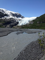
| View from Glacier View |
After about 0.6 miles you come to the Glacier View viewing area with an excellent view of the Exit Glacier. This is one of the two best vista photo opportunities. There is a nice bench here and it would be a nice place to stop for a snack and to enjoy the view.
 |
| Stream on Exit Glacier Trail |
The groomed trail continues past Glacier View, but, although it is still an excellent, well-groomed trail, it is no longer wheelchair accessible as it both narrows and steepens. Shortly after leaving Glacier View, the trail crosses and pretty little stream.
About 0.1 miles from Glacier View the trail splits. One trail goes to the Toe of the Glacier and the other goes to the Edge of the Glacier. We took the Edge of the Glacier trail.
The first part of the trail meanders back through the cottonwood forest and across a pleasant stream that feed the glacier river. About 0.3 miles along the trail it breaks out of the forest onto an open, rocky region that is the side of the mountain. At this point the glacier is clearly visible ahead and to the right. The trail winds up the mountain with a moderate incline heading toward the glacier edge.
 |
| Exit Glacier valley |
There are lovely views of the glacier, the glacier valley, and the glacier river. The trail eventually ends at an overlook about 500 ft from the side of the glacier.
From the Edge of the Glacier trail you can get a good view of the toe of the glacier. At the time we were there the glacier still had a thick covering of winter snow and several waterfalls running down and, in one case, out of the glacier.
 |
| Toe of the Glacier |
Based on the view, we decided that the toe of the glacier view wasn’t worth the hike on that particular day, so we chose not to do the Toe of the Glacier hike.
On the way back, just before the turn off to the Glacier View hike, the trail split. One path was the Glacier View Trail; the other was a paved road that led back to the ranger station. This time we took the paved road. The road passed straight through the cottonwood forest. It was a pleasant and easy walk, but hotter, and nowhere near as interesting as the Glacier View Trail.
| |

|
|
No comments:
Post a Comment